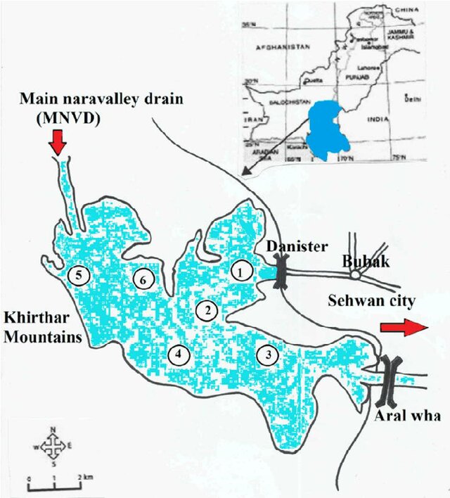
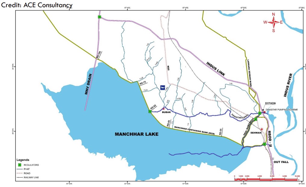
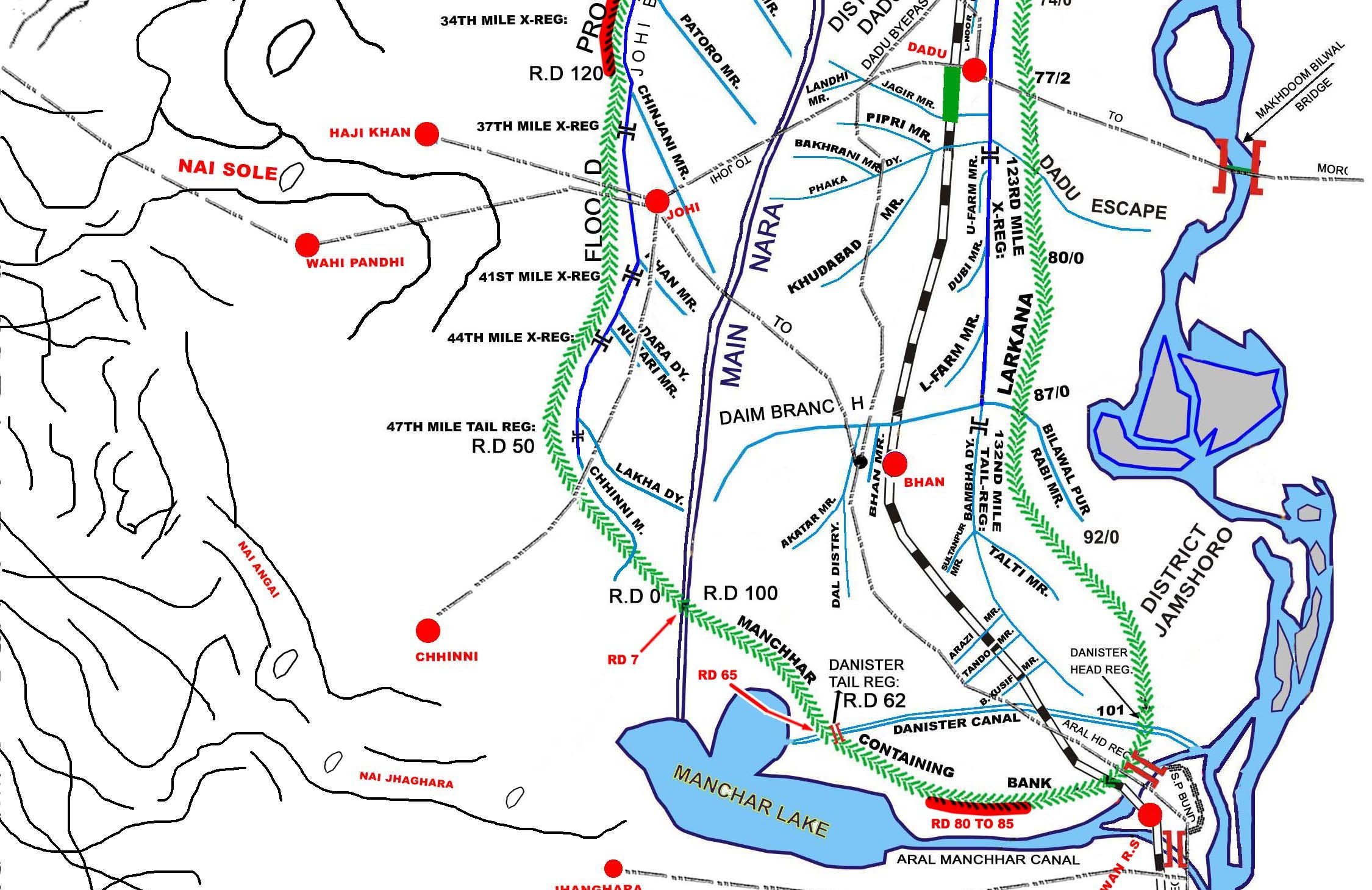
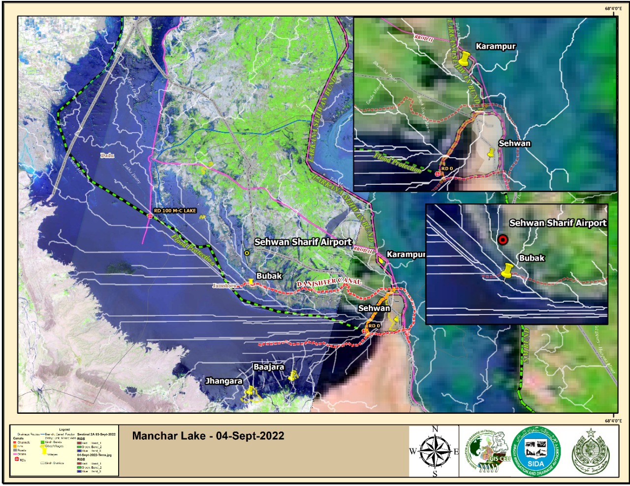
MANCHAR LAKE
INTRODUCTION : Manchar Lake is the largest natural freshwater lake in Pakistan and one of the largest in South Asia1. It is located west of the Indus River, in Jamshoro District and Dadu District, Sindh - 18 km away from Sehwan. The lake collects water from numerous small streams in the Kirthar Mountains and then empties into the Indus River. The lake’s surface area fluctuates with the seasons, from as little as 36 km² to as much as 500 km² during monsoon rains.
The lake’s banks and vicinity are home to ancient archaeological sites such as Ghazi Shah, Wahi Pandhi Ali Murad Mound1. The sites of Lal Chatto, Mashak Lohri, and Lakhiyo situated along the edge of Lake Manchar are the most ancient sites, which date from the Harappan culture1. The lake was formed when a branch of the Indus River flowed from Kashmore. In 1921, it was connected to Hamal Lake via the Main Nara Valley Drain.
Manchar Lake Levels
MANCHAR LAKE Plain & Flood 2022 Maps
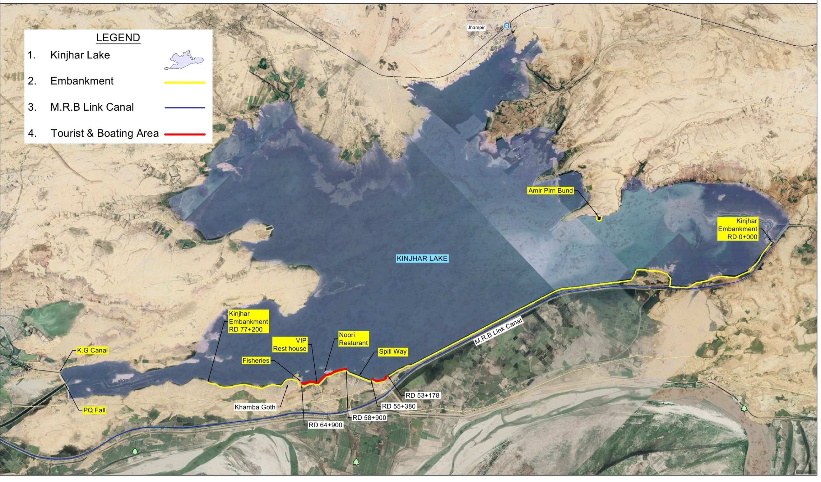
Kinjhar Lake
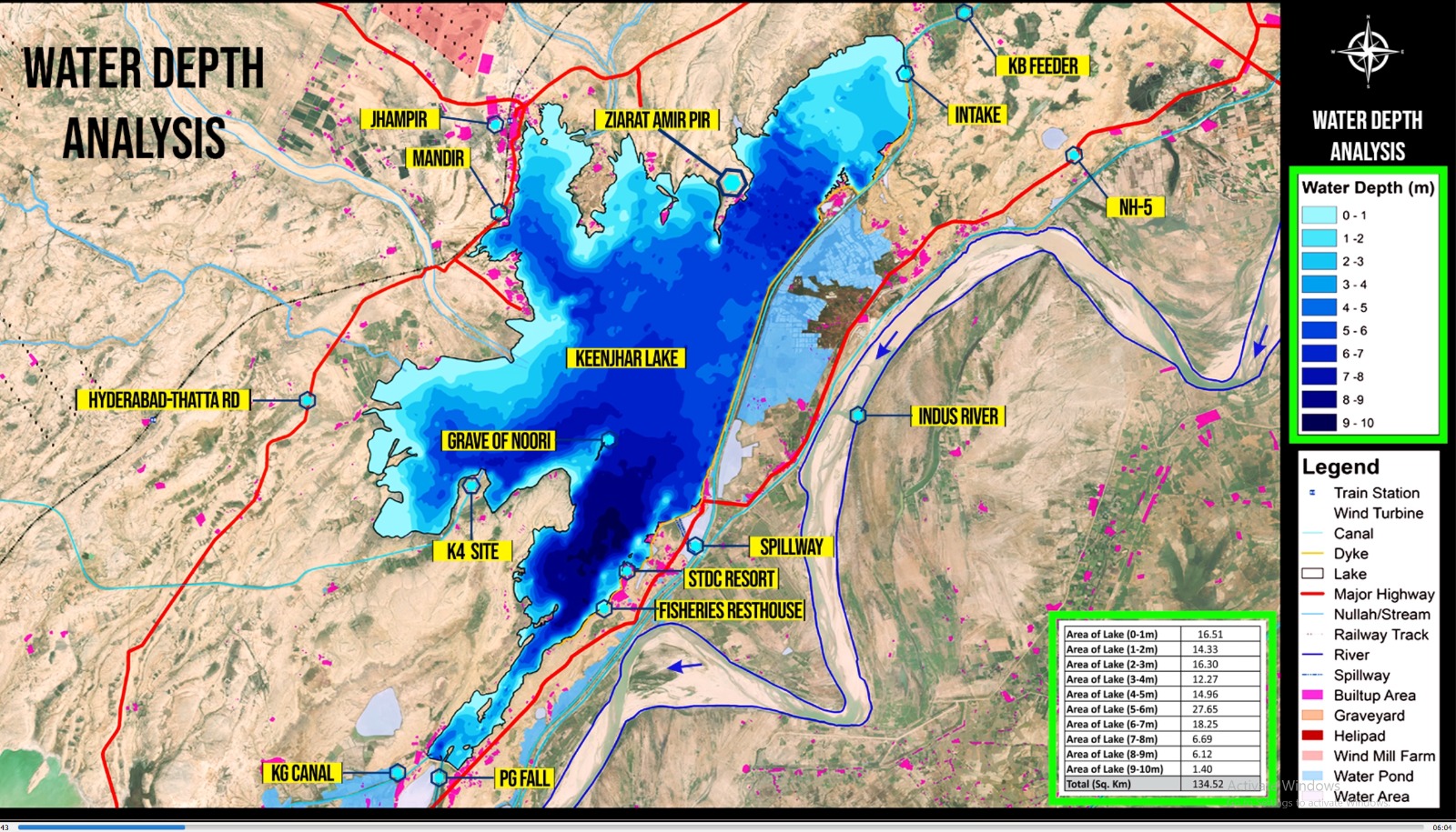
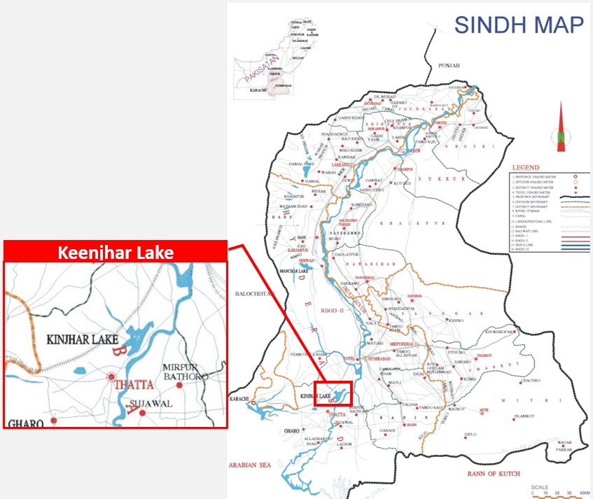
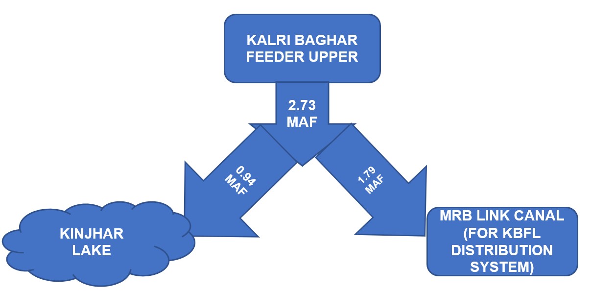
Introduction : Keenjher Lake, also known as Kalri Lake, is situated approximately 22 kilometers away from Thatta, 122 kilometers from Karachi, and 80 kilometers from Hyderabad. This lake is artificially created and is fed by the Kalri-Baghar Feeder Upper, sourced from the Right Bank of Kotri Barrage. Covering an area of 52.00 square miles at various water levels, Keenjhar Lake was formed by constructing earthen embankments with a length of 77 RD and a height of 25 feet, utilizing natural depressions like Sonheri and Keenjhar.
The main purpose of this artificial reservoir is to ensure a reliable water supply for domestic and industrial use in Karachi, accounting for approximately 80% of the city's total requirement. The Irrigation and Power Department provides 1200 cusecs of silt-free water through the Keenjhar-Gujjo canal from Keenjhar Lake, with the canal having a discharge capacity of 1382 cusecs.
LAKE TECHNICAL & OPERATION OVERVIEW
| Area of Lake at R.L 54.0 | 52.00 Sq. miles |
| Gross storage capacity | 0.558 MAF Before Project
0.660 MAF After Project(RL 57) |
| Live storage capacity | 0.38 MAF |
| Average depth of water | 20 Ft |
| Maximum height of embankments | 34.00 Ft |
| Length of embankments | 15.00 Miles |
| Deposition of silt per year | 4335 Ac.ft |
| Original Design Life | 132 Years |
| Reduction of life after siltation | 87 Years |
| Life after construction of Link Canal by passing Keenjhar Lake | 192 Years |
| Elevation (Ft) | Area (Sq. Miles) | Volume (MAF) |
|---|---|---|
| 30 | 11.01 | 0.029 |
| 32 | 17.39 | 0.047 |
| 34 | 23.68 | 0.073 |
| 36 | 26.8 | 0.106 |
| 38 | 29.3 | 0.142 |
| 40 | 31.68 | 0.181 |
| 42 | 34.59 | 0.223 |
| 44 | 37.69 | 0.27 |
| 46 | 40.86 | 0.32 |
| 48 | 44.25 | 0.374 |
| 50 | 46.63 | 0.433 |
| 52 | 48.91 | 0.494 |
| 54 | 51.29 | 0.558 |
| 56 | 53.72 | 0.625 |
| 57 | 54.83 | 0.66 |
| SALIENT FEATURES OF KALRI BAGHAR FEEDER UPPER | |
|---|---|
| The main feeding source of the Lake is Kalri-Baghar Feeder (upper) which off- takes from right bank of Kotri Barrage . | |
| Design Discharge | 9100 Cusecs |
| Full Supply Level | 67.0 Ft |
| Full Supply Depth | 15.0 Ft |
| Design Bed Level | 52.0 Ft |
| Design Bed Width | 195 Ft |
| Nos. of Span | 6.0 Nos. |
| Width of Span | 24.0 Ft |
| CCA | 603000 Acres |
| Length of Canal | 38.0 Miles |
| Cutoff | 13.80 Ft |
| Pavement Level | 52.0 Ft |
| Cill level | 56.0 Ft |
Karachi Water & Sewerage Board (KW & SB) initiated different projects time to time in order to meet out the present and future demand.
| Project Name | Discharge (Cs) | Cumulative Discharge (Cs) |
|---|---|---|
| K-I | 520 | 520 |
| K-II | 380 | 900 |
| K-III | 300 | 1200 |
| K-IV | 1200 | 2400
( under process) |
| A. Computation | |
|---|---|
| Before the Project | |
| I) Computation at RL 54.0 ft. | |
| Area of water in Lake sq miles | = 51.29 sq. miles - (Area Capacity Curve) |
| Volume of water Lake MAF | = 0.558 M.A.F - (Area Capacity Curve) |
| = 558000 A.F | |
| After the Project | |
| II) Computation at RL 57.0 ft. | |
| Area of water in Lake sq miles | = 54.83 sq. miles- (Area Capacity Curve) |
| Volume of water Lake MAF | = 0.66 M.A.F - (Area Capacity Curve) |
| = 660000 A.F | |
| B. Additional Water Availability after the Project | |
| Total Additional Water Availability for a period of year | = 660000 – 558000 |
| = 102000 Acre ft. | |
| Additional Water Available per period for a period of one year | = 102000/ (1.98* 365) |
| in cusecs | = 141.14 ft3/sec |
| Thus, Quantity of Additional Water Availability for six months | = 141.14*2 = 282.28 cusecs |
| Thus, Quantity of Additional Water Availability for four months | = 141.14*3 = 423.42 cusecs |
| Critical period of four months i.e. from November to February in which water supplied to Keenjhar Lake from Upper K.B Feeder is reduced, during this period; a quantity of 423 cusecs will increase the supply of K.B Feeder for supply to Karachi for a period of 120 days. Presently KW&SB is drawing un-interrupted water supply of 900 cusecs daily through Keenjhar-Gujjo Canal. Therefore if additional quantity of 423 cusecs is made available then it will meet with the present demand of water supply for Karachi i.e. 1200 cusecs as envisaged by KW&SB in their K-3 project. | |
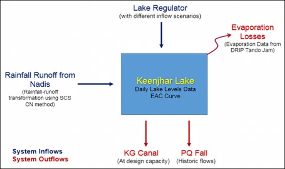
Inflow from Kalri Baghar Feeder Upper (KBFU) to Keenjhar = 0.94 MAF
| Rainfall contributions from Hill torrents approximately 50,000 acre- ft has been estimated from the nullahs draining into the Lake | = 0.05 MAF |
| Direct Rainfall on Keenjhar lake having Area(33280 acres) | = 0.033 MAF |
| Total Inflow in MAF= 0.94+0.05+0.033= 1.02 MAF | |
| In Kharif Season | |
| Total Outflow 825 MGD = KG Canal (600 MGD) and PQ Fall (225 MGD) | = 0.554 MAF |
| In Rabi Season (6 Month) | |
| Total Outflow 600 MGD = KG Canal (460 MGD) and PQ Fall (140 MGD) | = 0.400 MAF |
| Total Losses at the Rate of 7 % | = 0.0726 MAF |
| Total Outflow = Kharif Season + Rabi Season + Losses | |
| =0.554 + 0.400+ 0.0726 = 1.02 MAF | |
| In Kharif Season | |
| Total Outflow/Demand 1085 MGD = KG Canal (885 MGD) and PQ Fall (225 MGD) | = 0.729 MAF |
| In Rabi Season (6 Month) | |
| Total Outflow/Demand 910 MGD = KG Canal (720 MGD) and PQ Fall (190 MGD) | = 0.608 MAF |
| Total Losses at the Rate of 7 % | = 0.0826 MAF |
| Total Outflow = Kharif Season + Rabi Season + Losses | |
| 0.729 + 0.608+ 0.0826 = 1.42 MAF | |
| Reservoir Storage = 0. 80 MAF | |
| Total = 2.22 MAF | |
-
Inflow from Kalri Baghar Feeder Upper (KBFU) of 6000 Cusecs to Keenjhar (with in Three Month)
=1.07 MAF -
Inflow from Kalri Baghar Feeder Upper (KBFU) of 2000 Cusecs to Keenjhar (with in Eight Month)
= 0.952 MAF -
Rainfall contributions from Hill torrents approximately 50,000 acre- ft has been estimated from the nullahs draining into the Lake
= 0.05 MAF -
Direct rainfall on Keenjhar lake having Area(33280 acres)
= 0.033 MAF - Total Inflow in MAF= 1.07+0.952+0.05+0.033= 2.11 MAF
Kinjhar lake Levels
KINJHAR LaKE Maps